GPRS 3D Laser Scanning Industries Served Overview
GPRS is a leading provider of 3D laser scanning services, providing as built, 2D CAD drawings, 3D BIM models, and 3D mesh models for buildings, plants, facilities, infrastructure and jobsites. We provide architecture, engineering and construction professionals accurate data and exceptional service to expedite design planning, prefabrication, asset management and facility modifications.
We possess the resources, experience and capabilities to provide a complete range of 3D laser scanning and scan-to-BIM services. The combination of accurate laser scanning and modeling is an asset that provides value throughout the planning, design and execution phases of any project. It helps our clients to plan for future enhancements without the expense and worry of unknown interferences and conflicts.
Featured 3D laser Scanning Services

As Built Construction Services
An as built survey capturing exact dimensions and locations proves to be invaluable in design, construction, renovation, prefabrication, and facility modifications.
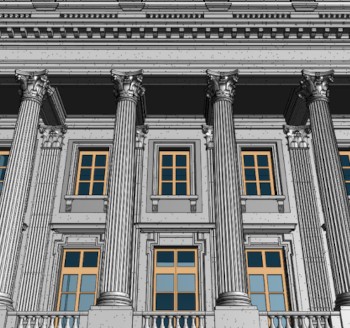
Architectural Laser Scanning
3D laser scanning aids the process of architectural design from site documentation, to monitoring construction progress, creating design models, and verifying as built accuracy.

BIM Modeling
Precision point clouds are used to develop intelligent BIM models, giving AEC professionals insight and tools to more efficiently plan, construct, and manage buildings and infrastructure.

Concrete Laser Scanning
Whether you are performing concrete inspection, layout or documentation, we deliver solutions to expedite your project. Collect and share project data with 3D laser scanning.

Construction Laser Scanning
Accurate existing building conditions is essential for construction planning. Data can also be used to compare the newly constructed work against the as-designed model or drawings.

Historical Laser Scanning
Laser scanning captures structural and architectural details of historic buildings and sites with 2-4mm accuracy in the form of point clouds, 2D CAD drawings and 3D BIM models at any level of detail.

Power, Process and Plant
Receive accurate and reliable data and deliverables documenting the interior and exterior of facilities; structural and MEP features; furnaces, equipment, conduit and piping down to ½ inch diameter.

Mixed Reality and Video Gaming
3D laser scanning can collect millions of data points to provide software developers with incredible details to create more realistic and engaging mixed reality experiences.
Additional 3D Laser Scanning Services

Agricultural Facilities
From engineering grain intake and distribution towers, to replacing ducts and piping for a grain chute, to analyzing tank farm slab elevation contours, GPRS has the resources to create a solution unique to your business needs.

Water and Wastewater Treatment Plants
Document and 3D model 40 MGD to 1 BGD Water and Wastewater Treatment Plants, including foundations, structural and MEP features, equipment, conduit and piping down to ½ inch diameter.

Stadiums and Theatres
Point cloud data and highly accurate 3D models can be created for any football stadium, basketball court, baseball park, golf course, ice rink, theatre, and arena to aid in design planning, renovation, and construction management.

Healthcare and Pharmaceutical
3D laser scanning captures exact building dimensions, locations and layout, information that is crucial for facility modifications, plant maintenance, renovation, prefabrication, asset management, and so more.

Overhead Clearances
Measuring overhead obstructions is fast, safe, and accurate with 3D laser scanning. Technicians calculate overhead clearances from the ground without coming into contact with energized power lines.

Energy and Utilities
3D laser scan building infrastructure: structural, mechanical, electrical and plumbing features; furnaces, equipment, conduit and piping down to ½ inch diameter. We work with municipalities, engineering firms, and privately owned facilities.

Schools, Colleges and Universities
With our extensive BIM experience, as built information is captured on universities, colleges and high schools to support site renovations and upgrades. The ability to coordinate construction plans saves time and cuts costs.

Oil and Gas
High definition laser scanning for the interior and exterior of buildings; structural, mechanical, electrical and plumbing features; equipment and piping down to ½ inch diameter; and any other site topography.

Government and Defense
GPRS offers reality capture and BIM solutions that help government and defense contractors tackle even the most complex projects with confidence.

Telecommunications and Transmission Lines
Inventory, document and model telecommunication towers or telephone lines quickly, accurately, safely and cost-effectively.

3D Projection Mapping
GPRS captures accurate point cloud data and generates a 3D mesh model containing basic architectural elements for clients to incorporate into 3D projection mapping.

Accident Reconstruction
GPRS laser scanning experts use state-of-the-art laser scanning equipment and drone photogrammetry to analyze complex accident sites and incident scenes.

Advanced Analysis
3D laser scanning provides quantitative and definitive measurement data, removing human error from the collection process. The exact dimensions and locations of the most complex project details can be recorded with 2–4-millimeter accuracy.

Above and Below Ground Data Capture
Receive complete site and facility visualization, both above and below ground with the combination of 3D laser scanning, utility locating, concrete scanning, video pipe inspection, and leak detection.

Drone Services
With two licensed pilots on staff, GPRS offers aerial drone video and photogrammetry services, providing data acquisition in large, hard to reach or dangerous areas.
Industries We Serve
- Construction
- Engineering
- Architecture
- Industrial Facilities
- Historical Preservation
- Agricultural Facilities
- Chemical and Petrochemical Plants
- Commercial Sites
- Government, Defense and Military Sector
- Healthcare and Pharmaceutical
- Manufacturing and Assembly Facilities
- Office Buildings
- Overhead Clearances
- Process Plants
- Power Plants
- Refineries
- Schools and Universities
- Stadiums and Theatres
- Space and Aeronautics
- Telecommunications
- Water and Wastewater Treatment Plants
- Mixed Reality, 3D Gaming and Software Development
Clients We Serve
- Architects
- Asset Managers
- Contractors
- Designers
- Developers
- Electrical Engineers
- Estimators
- Facility Owners
- Historical Preservationists
- Mechanical Engineers
- Project Managers
- Plumbing Engineers
- Sub-Contractors
- Structural Engineers
- 3D Gamers and Software Developers
- Virtual Design and Construction (VDC) Managers
Deliverables
- Point Cloud Data (Raw Data)
- 2D CAD Drawings
- 3D Non-Intelligent Models
- 3D BIM Models
- 3D Mesh
- TruView - photos overlaid on point cloud
- Fly-Thru's - 3D virtual tour of model
- Template Modeling
- Reconciliation of Clients 2D Drawings
- Reconciliation of Clients 3D Design Model
- Comparative Analysis
- Point Cloud Modeling Training Webinars
- Deviation / Deformation Analysis
- Floor Flatness Analysis / Contour Mapping
- Drawings / Analysis to Aid Prefabrication
- Volume Calculations
- Structural Steel Shape Probability Analysis
- Wall Plumb Analysis
- Tank Analysis
- Forensic Analysis
- Aerial Photogrammetry
- New Construction Verification
- Digital Drawings of GPR Marking
- To learn more about deliverables, click here.
3D Laser Scanning Pricing
The cost of 3D laser scanning can vary widely depending on your project scope. GPRS customizes every quote specific to your project’s needs. GPRS Project Managers use 3D laser scanners to capture every detail of your site, delivering building dimensions, locations, and layout with millimeter accuracy. This can include the aboveground structural, architectural, and MEP features, plus underground utility and concrete markings. Our Mapping & Modeling Team can deliver point clouds, 2D CAD drawings, 3D BIM models, 3D Mesh models, TruViews, and Virtual Tours at any level of detail.
Contact us today to see the expertise and value that GPRS Laser Scanning can provide at Laser@gprsinc.com or call 419-843-7226 (SCAN). We’re currently offering 10-minute presentations – would you like to schedule one? Click here.