Point Clouds Explained
What is a Point Cloud?
A point cloud is the set of 3D data points captured by a laser scanner. It contains the X, Y, and Z coordinate of every visible detail of the project site. The data captured will look like a pixelated, digital version of the asset. To visualize the project, point cloud data is imported into CAD software. Once imported, it can be parsed, manipulated, and modified to aid in visualization, design, engineering, and construction projects.
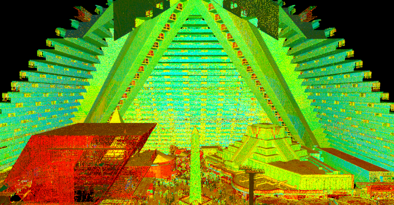
Intensity map point cloud data of the Luxor Hotel in Las Vegas.
How do you create a point cloud?
There are many different laser scanning systems available to create a point cloud. Among these are Leica professional-grade laser scanners, NavVis mobile mapping scanners, and the Matterport Pro 3. To capture complete project data, the scanner must be positioned around the site from varying viewpoints. Millions of data points are captured and processed into a point cloud, creating an accurate data set of the structure or site. This process is completed by a trained technician to ensure proper collection of data and correct scanning methods. Read more about laser scanning equipment here.
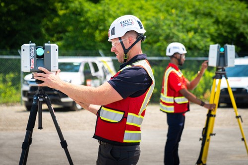
Laser scanners capture 3D data points that create a point cloud.
Why is a point cloud important?
Point clouds provide powerful and dynamic information for a project. By representing spatial data as a collection of coordinates, point clouds deliver large datasets that can be mined for information. The visualization and analysis from point cloud data is invaluable for decision making. CAD technicians transform point clouds into customized deliverables used for visualization, analysis, design, construction, renovation, prefabrication, and facility modifications.
How long does it take to create a point cloud?
It depends on the project scope. Most projects can be laser scanned in a couple of hours, or larger campuses in a few days. After the scan is complete, the data must be registered and will then be uploaded to the client. This process can take 2-3 days. 2D sheets and 3D models can be created from the point cloud data. This will take additional time from experienced CAD designers.
Can a point cloud be created in color?
Data can be captured in intensity (RGB), greyscale (black and white) and full color. Color point clouds combine the benefits of a photo (or photogrammetry) with the precision of laser scanning. To complete a full color laser scan, the building or site must have good lighting. Read about the benefits of scanning in color, here.
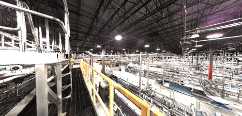
Colorized point cloud of a manufacturing facility.
How do you process a point cloud?
Registration is the process of compiling individual scans into a cohesive point cloud. It involves taking the raw scan data collected onsite and “stitching it together” to produce a complete 3D composite point cloud of the existing conditions. Getting the registration right ensures the most accurate measurements, and precise 2D drawings and 3D models. This is an important part of the process, and it must be completed by an experienced individual. Once complete, the registered point cloud provides accurate documentation of the as-built space with millimeter accuracy. Read more about the importance of registration, here.
What formats are point clouds delivered in?
There are many file formats and each one has particular strengths and weaknesses depending on the method of capture and software used. Different scanners produce raw data in multiple formats, and each piece of software has different exporting capabilities. Popular formats are .PTG or .E57 point cloud files and Autodesk Recap files in .RCS and .RCP format.
What can be done with the point cloud data?
To create advanced deliverables, data is imported into a CAD/BIM software, such as Autodesk, where the data is turned into 3D solids and surfaces. The process of transforming point clouds into 3D models or digital twins takes time and requires an experienced CAD technician. Custom deliverables, such as 2D drawings and 3D models, can be provided at any level of detail. Read more about laser scanning deliverables, here.
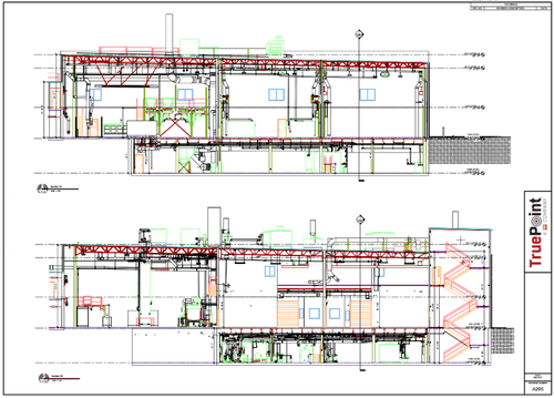
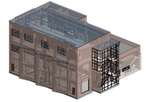
Custom deliverables, such as 2D drawings and 3D models, can be provided at any level of detail.
What are the applications of point cloud data?
Point cloud data has become the new standard in design planning for the architecture, engineering and construction industry. Having a virtual model of the project gives companies the ability to effectively plan, design, construct, and manage projects. Point cloud data aids in analysis, design, construction sequencing, renovation, prefabrication, asset management, and facility modifications, to name a few. Precise point clouds expedite design planning and reduce project costs and change orders.
In summary
3D laser scanners use LiDAR technology to measure and record precise locations and distances, ultimately producing a point cloud file. The technology produces highly accurate digital measurements of assets for use in construction and engineering projects. For questions on point clouds or 3D laser scanning services, contact us today at 419-843-7226 or Laser@gprsinc.com. We’re currently offering 10-minute presentations – would you like to schedule one? Click here.