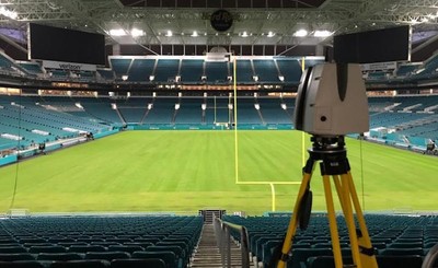
What Is 3D Laser Scanning?

3D laser scanning delivers complete and accurate as-built site information prior to the design and planning of your construction project.
What is 3D Laser Scanning?
3D laser scanning delivers complete and accurate as-built site information prior to the design and planning of your construction project. 3D laser scanners capture every detail of your site – the structural, architectural, and MEP features, plus underground utilities, and concrete reinforcements – at incredible speeds with unparalleled accuracy. 3D laser scanning delivers an overall site plan capturing exact building dimensions, locations, and layout.
How Does a 3D Laser Scanner Work?
3D laser scanners use LiDAR (light detection and ranging) technology to map millions of data points of a project site. The primary way a laser scanner works is to send light pulses at high speeds which reflect off objects and return back to the scanner’s sensor. For each pulse, the distance between the scanner and object is measured by determining the elapsed time between the sent and received pulses. Each data point is converted to a pixel with a known x, y, and z coordinate.
Millions of data points from multiple positions and viewpoints are captured and processed into a point cloud, creating an accurate 3D as-built data set of the site. This all happens very quickly, with some scanners, like the Leica RTC360, capturing and calculating 2 million data points per second with 2-4 mm accuracy. The result is a complete and accurate set of real-time data which can be mined for information or processed into customized 2D CAD drawings and 3D BIM models at any level of detail.
3D laser scan technology provides a clear, cost-effective solution to your as-built and facility visualization needs. It can reduce and even eliminate costly errors to speed up your design, engineering, and construction processes. 3D laser scanning delivers the level of detail for construction, renovation, design planning, prefabrication, asset management, and facility modifications.

Millions of data points from multiple positions and viewpoints are captured and processed into a point cloud.
What are the Applications of 3D Laser Scanning?
- As-builts, reality capture, and existing conditions data
- Construction verification, sequencing, scheduling, and simulations
- Design engineering for facility upgrades or expansions
- 2D and 3D laser map of a building
- Prefabrication
- Clash detection
- Architectural documentation or historical preservation
- Calculating volumes, deformation analysis, and overhead clearances
- Virtual design and construction
- Laser scanning for facility coordination
- Collecting geospatial data
- Creating a digital twin
- Performing advanced analysis to easily aggregate, query, visualize, and analyze data in a 3D model
- Augmented & Mixed Reality (AR & MR) for video games, television, film, and sports enhanced fan experiences
Knowing which application you need determines what 3D laser scanner is used on site, the necessary resolution of the point cloud and photography, and what kind of maps, models, drawings, or other deliverables your project requires.
What are the Benefits of 3D Laser Scanning?
3D laser scanning accelerates the as-built data capture process compared to traditional surveying methods. Laser scanners can quickly capture millions of data points within minutes, providing comprehensive data of the building or site.
- Fast collection of site data with the highest-quality survey-grade laser scanners
- Expedite planning and design with accurate as builts
- Capture exact dimensions and measurements of your project site
- Eliminate site disruptions and revisits
- Receive precise point clouds, 2D CAD drawings, and 3D BIM models to improve collaboration and coordination
- Tour the location, add digital notes, and even measure with a virtual tour
- Reduce project risks, change orders, delays, and costs
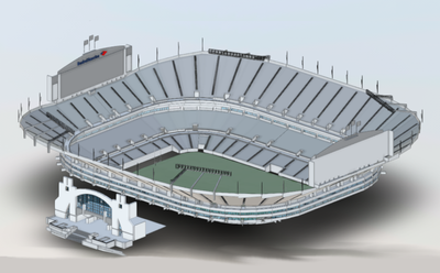
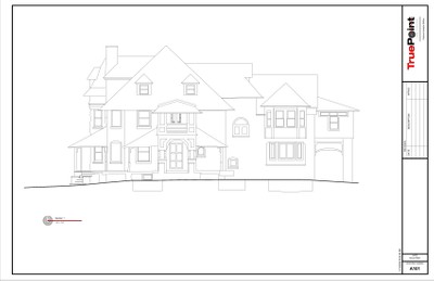
What Can Be Created from the Point Cloud?
Point clouds can be transformed into custom 2D CAD drawings, 3D BIM models, 3D mesh models, TruViews, and virtual tours, delivering the exact dimensions, locations, and layout of your site.
- Point Clouds can be delivered in a wide range of file types to be used in many different software packages, including Bentley, Autodesk, and more.
- 2D CAD Drawings can be generated by importing the point cloud data into AutoCAD software to create floor plans, sections, and elevations to use for construction planning and building modifications.
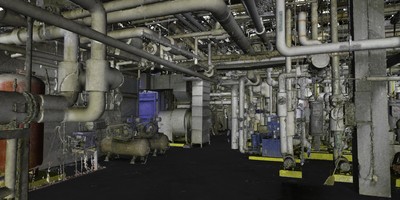
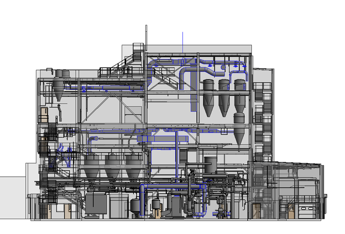
- 3D BIM Models deliver a geometrically accurate model of a building or site, capturing infrastructure, spatial relationships, maintenance information, product models, as well as additional property and layer information.
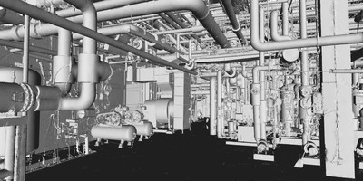
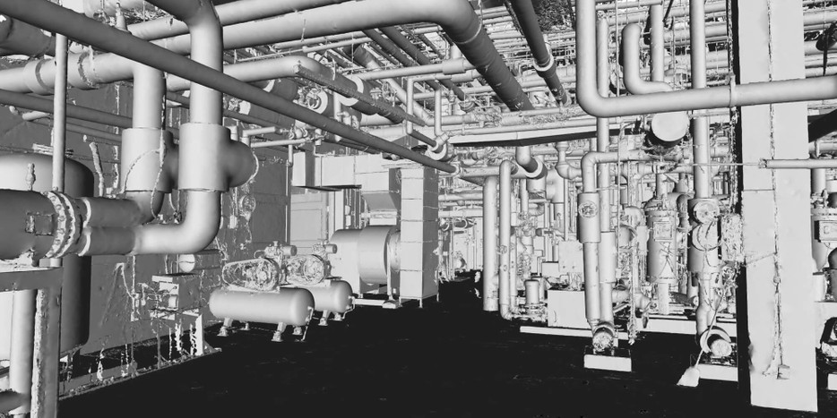
- 3D Mesh Models allow you to view a site’s geometry inside a CAD environment without having to navigate a point cloud.
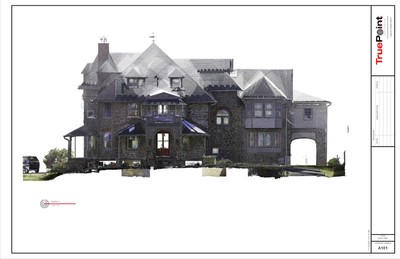
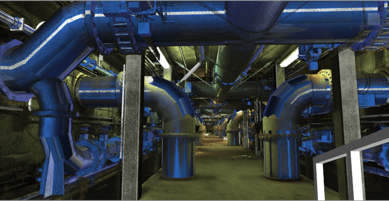
- TruViews are 3-dimensional photographs overlaid on top of the point cloud data. A TruView let’s you navigate a site, add markups and GeoTags, plus visualize designs in context to check design models against real work conditions.
- 3D Virtual Tours like allow your team to virtually walk-through a site or facility in minutes, take basic measurements, estimate clearances and distances, and add digital notes.
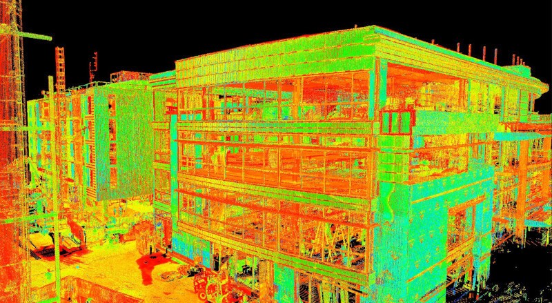
Point Cloud
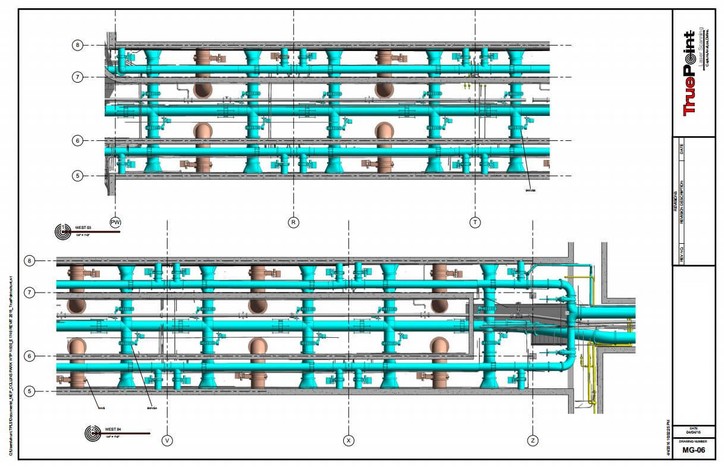
2D CAD Drawings
3D BIM Models
3D Mesh Models

TruViews
3D Virtual Tours
How Much Does 3D Laser Scanning Cost?
Customized quotes are developed for each client based on the scope of the project and the deliverable requested. The cost of 3D laser scanning can vary widely depending on your project scope. GPRS customizes every quote specific to your project’s needs. GPRS Project Managers use 3D laser scanners to capture every detail of your site, delivering building dimensions, locations, and layout with millimeter accuracy. This can include the aboveground structural, architectural, and MEP features, plus underground utility and concrete markings. Our Mapping & Modeling Team can deliver point clouds, 2D CAD drawings, 3D BIM models, 3D Mesh models, TruViews, and Virtual Tours at any level of detail.
Why Choose Us? The GPRS DIFFERENCE.
You can trust our team to provide the best experience in laser scanning by walking you through the entire 3D laser scanning process from pre-planning through project completion.
We offer a consultative approach to project management, working with you to ensure our data, maps, and models are the perfect solution for your project. The data delivered is accurate within millimeters, and the maps and models provide complete as built and location data.
Our elite team of Project Managers is required to complete an extensive training program before performing field services on your job site. Every Project Manager completes 80 hours of classroom training and 320 hours of field mentoring.
All GPRS team members work together to help you Intelligently Visualize The Built World® to help you reduce change orders and costs so that your projects come in on time and on budget. We are the best at what we do because it is all we do.
For more information on 3D laser scanning services, contact GPRS today at laser@gprsinc.com or 419-843-7226. We’re currently offering 10-minute presentations – would you like to schedule one? Click here.
Watch Our Video: What is 3D Laser Scanning Explained
3D laser scanning is a construction, engineering, and architectural tool often used to document the existing conditions of any site. 3D laser scanners use LiDAR technology to measure and record precise locations and distances, ultimately producing a point cloud file.
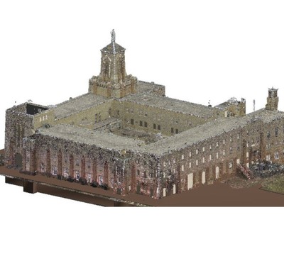
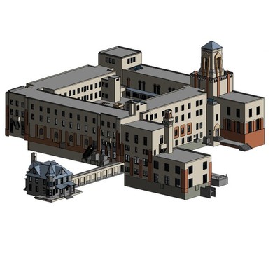
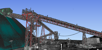
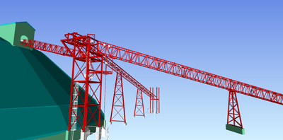
Sample 3D Laser Scanning Projects by GPRS
The comprehensive point cloud obtained by 3D laser scanning can be created into intelligent 2D CAD drawings, 3D BIM models, 3D mesh models, TruViews, and virtual tours to facilitate design planning, communication and collaboration. Check out these sample projects to see the expertise and value that GPRS 3D Laser Scanning can provide.