What is Virtual Design and Construction?
According to Stanford University, Virtual Design and Construction (VDC) uses 3D models to design an AEC project virtually prior to construction, facilitating better planning and management.
Virtual design and construction was developed by professor Martin Fischer, the Director of Stanford University’s Center for Integrated Facility Engineering, in 2001. VDC is the process of using digital models of buildings and sites to collaborate on the design, process, schedule, and budget of a project before construction begins. The virtual design and construction process begins by 3D laser scanning a site. Millimeter-accurate existing conditions data is collected in the form of a point cloud and processed into an intelligent 3D BIM model. Design teams utilize the structural, architectural, MEP, and underground utility models to plan the construction of the project in a virtual environment, sequence and analyze constructability, and perform clash detection.
How are 2D CAD Drawings Created?
Prior to VDC technology, paper documents, such as 2D CAD drawings, paper plans, and spreadsheets were used in construction. Paper plans are produced by using a tape measure to manually record building dimensions and measurements. Manual measuring requires at least two people, countless man hours, the proper application of tools, an excellent memory, and accurate transcription. Still, it’s nearly impossible to get right.
For some projects blueprints exist and can be converted to CAD. This requires accurately transcribing the dimensions from the original PDF floor plan, including the internal dimensions of every room, plus wall thickness and system components to plan for renovation.
2D CAD drawings are time consuming to produce; it can take weeks or months to produce a complete set of CAD drawings for a project. For design planning, any change must be documented and communicated, which impacts the schedule and productivity.
Another serious drawback to working with paper CAD drawings is the accuracy of the data that was used to produce them. Manual measurements, or even laser-aided DISTO measurements, can be off by as much as a foot. That's why general contractors are forced to build in downtime and pad their budgets to allow for change orders and reworks once construction is underway.
A study reported in Engineering News-Record (ENR) in August of 2022 calculated as much as $177.5 billion per year in lost labor costs to fix mistakes in the construction industry and two full days per week of time lost to related delays.
Virtual design and construction is a modern approach to designing and managing the project, materials, and contractors. VDC can be used throughout the entire lifecycle of a project, from design, to construction, through operations to asset modifications. BIM models are the basis for virtual design and construction, and are utilized to communicate design plans and construction workflows to the project team.

Prior to the adoption of VDC technology, paper documents, such as 2D CAD drawings, paper plans and spreadsheets were used in construction.
How is a BIM Model Created?
A BIM model (building information model) is an intelligent three-dimensional model of a physical building that contains data about that building.
BIM models are the 3D digital model of the physical asset and are essential for virtual design and construction planning. Teams are able to collaborate, design, and plan construction sequencing with BIM models.
Before a BIM model is created, the building or site must be 3D laser scanned. Laser scanning uses LiDAR technology to map the millimeter-sized data points of a site, producing a complete and accurate set of site conditions or digital twin of the environment.
Both BIM models and digital twins refer to 3D digital representations of physical spaces. Unlike Building Information Modeling (BIM) diagrams, which show its many systems and subsystems, digital twins show space. Where BIM focuses on how the building is constructed, digital twins focus on how people will use the space. 3D BIM models are used for planning the design and construction, while digital twins are used for visualization and analysis.
3D laser scanning is the most effective method to capture and accurately record a building’s infrastructure both above and below ground, including dimensions, geometry, and spatial layout. GPRS 3D laser scanning services deliver 2-4 mm dimensional accuracy for precise visualization and superior clash detection.
Underground utilities can be located and mapped with GPR and EMI technology, including water lines, sewer lines, gas lines, electrical lines, phone and cable lines, and more. GPRS has achieved and maintained a better than 99.8% accuracy rating on utility locates.
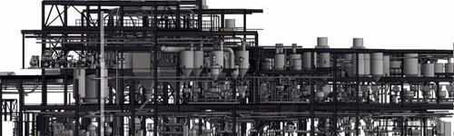
All above and below ground data collected can be processed into a 3D BIM model using software such as Autodesk Revit to show all structural and architectural details, MEP (mechanical, electrical, and plumbing) components, and utility locates.
Stanford University’s Center for Integrated Facilities Engineering reported the following benefits of BIM models (after gathering data on 32 major projects):
- Up to 40% elimination of unbudgeted change.
- Cost estimation accuracy within 3% as compared to traditional estimates.
- Up to 80% reduction in time taken to generate a cost estimate.
- A savings of up to 10% of the contract value through clash detections.
- Up to 7% reduction in project time.
What is the difference between VDC and BIM?
BIM is a process of documenting a digital representation of a building by incorporating both geometric and non-geometric information. Whereas VDC is a broader term that utilizes BIM and other digital tools throughout the lifecycle of a building. BIM is one of the key components of VDC, however, VDC is not limited to BIM. VDC can include the use of other digital tools, such as 3D laser scanning, point cloud data, and simulation software.

BIM models are the 3D digital model of the physical asset and are essential for virtual design and construction planning.
What are the Benefits of Virtual Design and Construction?
The benefits of Virtual Design and Construction include improved coordination between the project team, reduced potential for errors and reworks, enhanced safety planning and execution, and better management of construction resources.
The 3D BIM model provides the following benefits:
- Design planning and decision making are expedited with real-time virtual data
- Time and money are saved with accurate project plans
- Understanding of the project scope by all subs and stakeholders.
- Communication of design changes in real time with sharable data
- Identification of potential hazards before construction begins
- Increased coordination between design, engineering, and construction teams
Who Uses Virtual Design and Construction?
Virtual Design and Construction is used by AEC professionals to manage the planning, visualization, and construction of building projects.
The following stakeholders utilize VDC:
- Architects
- Engineers
- Contractors
- Owners and Clients
- Project Managers
- Facility Managers
- Construction Consultants
- Government and Regulatory Authorities
- Manufacturers and Suppliers
- Educational Institutions
VDC maps out the construction process digitally before it is built. VDC can help project stakeholders collaborate earlier and more effectively. By using intelligent 3D BIM models, AEC professionals can address common sources of risk before they lead to costly, time-consuming rework.
How Are Companies Using Virtual Design and Construction?
Stanford researchers say VDC is a valuable tool for complex building and infrastructure projects. According to Standford University, VDC workflows increase efficiency, improve reliability, and avoid common pitfalls. Teams apply VDC techniques to their own design, construction, and operational management. The following are a few examples of how companies are using virtual design and construction technology:
- Construction Documentation: Detailed 3D models of the entire construction project can be created, including architectural, structural, MEP systems, and utility locates. These models are created using specialized software that allows different project stakeholders to work together in a common digital environment.
- Data Integration: VDC goes beyond 3D modeling by integrating various data sources, such as cost estimates, scheduling information, material specifications, and project documentation. This integrated approach ensures that all project information is available in a single digital platform.
- Collaboration: VDC promotes collaboration among project stakeholders, including architects, engineers, contractors, and owners. Everyone can access and contribute to the digital model, which fosters better communication and coordination throughout the project's lifecycle.
- Visualization: VDC allows stakeholders to visualize the project in a virtual environment. This helps to identify design clashes, optimize construction sequences, and make informed decisions about design changes or modifications.
- Simulation and Analysis: Virtual models can be used for simulation and analysis purposes. For example, engineers can simulate the performance of structural systems, and energy analysis can be conducted to assess the building's electrical, gas, and insulation efficiency.
- Clash Detection: VDC software can automatically detect clashes or conflicts between different building systems, such as pipes conflicting with structural elements. This early clash detection helps prevent costly errors during construction.
- Prefabrication: VDC offers accurate data to spec and produce prefabricated materials off-site, ensuring a precise fit and flawless installation.
- Cost Estimation and Project Control: VDC can be used to generate accurate cost estimates based on the digital model, helping project managers to control budgets and monitor expenses throughout the project's life cycle.
- Scheduling and Time Management: VDC can assist in creating detailed construction schedules and optimizing the construction sequence. This leads to better time management and more efficient project execution.
- Facility Management: After construction, the digital model can be handed over to facility managers to support ongoing maintenance and operations. This allows for efficient facility management and reduces long-term operating costs.
What Role Does GPRS Play in Virtual Design and Construction?
GPRS is a leading provider of 3D laser scanning and utility locating services, delivering accurate as built documentation of buildings and sites, both above and below ground, with millimeter accuracy. Every GPRS Project Manager completes an extensive training program to ensure their competence in laser scanning and utility locating equipment and field knowledge to provide the best possible results for every project. All Project Managers also complete SIM, Subsurface Investigation Methodology training, requiring 80 hours of classroom/hands on training and 320 hours of mentorship in the field.
The GPRS Mapping & Modeling Team can create anything from a simple GPS-enabled locating map of your utility locate, to highly detailed 2D CAD drawings and 3D BIM models, depending on your needs for virtual design and construction.
GPRS stores all subsurface infrastructure data, plus a free PDF and .KMZ file when we conduct an underground utility locate, in a complementary SiteMap® subscription. You can access your data from any laptop or mobile device and securely share it with your team.
We deliver the precise data needed for VDC teams to collaborate on design planning, sequencing, and cost estimation of a project before beginning construction.
Virtual Design and Construction, Explained
VDC can help project teams collaborate at the start of the project. Planning occurs digitally before ground is broken in the real world. The project team of owners, designers, contractors, and subcontractors collaborate in a virtual environment, where they can evaluate designs and materials.
GPRS provides accurate data, point clouds, 2D CAD drawings, and 3D BIM models for virtual design and construction to help you Intelligently Visualize the Built World.

GPRS is a leading provider of 3D laser scanning and utility locating services, delivering accurate as built documentation of buildings and sites, both above and below ground, with millimeter accuracy.