Why Should You Incorporate Reality Capture into Your Construction Project
Accurate Site Data for Better Decision Making
The construction industry has come a long way. The manual, tedious, and often inaccurate process of creating as builts has been replaced with state-of-the-art technologies that deliver accurate site data for better decision-making. This technological breakthrough is 3D laser scanning, often referred to as reality capture or digital twin.
What is Reality Capture?
Reality capture produces a digital 3D model representation of a building or site after scanning it in the real world using long range 3D terrestrial laser scanners. Using laser scanning or photogrammetry methods, millions of surface points are measured and mapped to develop a high-resolution, geometrically precise 3D model. The result is a complete and accurate set of real-time data, which can be directly connected into design and visualization software.
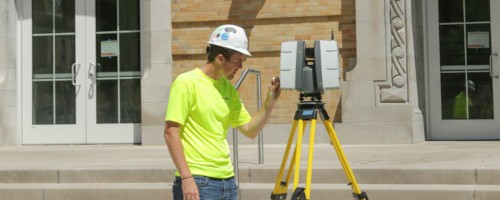
3 Steps for Reality Capture
- Capture
3D laser scanners use LiDAR technology to capture millions of data points of a project site. Scans are taken in multiple positions from varying viewpoints and processed into a point cloud.
- Process
From there, engineers register and clean the point cloud, and stitch it into a coordinate system to provide the most precise measurements.
- Model
Using BIM and CAD software 3D models are created from the actual site conditions. Engineers can design with confidence knowing the information is accurate.
What are the Benefits of Reality Capture?
- Removes guesswork
Reality capture via 3D laser scanning captures incredible site detail. Each point is captured and mapped onto an XYZ coordinate system for an intelligent survey output to remove any guesswork from decision making.
- It’s more than a documentation process
Reality capture transforms every point of the construction site into usable data. However, it doesn't stop there. Reality capture software offers cloud-connected tools to create a collaborative and interactive environment, allowing everyone to pitch in and do more with the captured data.
- Less trips to the jobsite
There is no need to take return trips to the construction site because of missed measurements. A 3D digitized replica, or digital twin, offers design and construction teams more time to design instead of spending time on doing tedious manual data capture.
Conclusion
With 3d laser scanning, photogrammetry and reality capture you can instantly document nearly every point of a construction site. Implementing reality capture for your building or infrastructure project minimizes labor, saves time and reduces project rework.
