What is a Point Cloud?

Point clouds provide an accurate map and layout of the building or site.
What is a Point Cloud?
If you're interested in 3D laser scanning your site’s as-built conditions, you might want to understand what a point cloud is. A point cloud is the set of 3D data points captured by a laser scanner -- it is the output of the 3D laser scanning process. Point clouds are obtained with 3D laser scanning technologies like LiDAR (Light Detection and Ranging), structured light scanning, or photogrammetry.
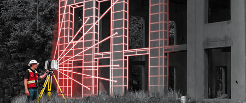
When 3D laser scanning a site, the scanner transmits a laser beam and hits an object, at which point the light is reflected back and captured by the scanner. Because light travels at a constant speed, the variation can be calculated at a distance, producing an accurate point in space.
To capture every visible detail of the site, the laser scanner must be positioned around the site from varying viewpoints. This process is completed by trained technicians to ensure proper collection of data and correct scanning methods. Millions of data points are captured and processed into a point cloud, creating an accurate data set of the site.
Point clouds provide an accurate map and layout of the building or site, including objects like doors, windows, walls, MEP equipment, ductwork and steel structures, to name a few. Each point captured by the laser scanner will be converted to a pixel with a known x, y, and z coordinate. Taken together, they represent every visible detail of a site.
For construction projects, it is important that point cloud data is obtained by high-end survey-grade laser scanners and equipment. There are many different laser scanning systems available to create a point cloud. GPRS employs Leica professional-grade laser scanners and the Matterport Pro 3.
Point clouds are obtained through 3D laser scanning technologies like LiDAR or photogrammetry.
Why is a Point Cloud Important?
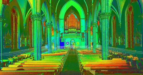
Point clouds provide powerful and dynamic information for a project, documenting every visible detail of a project site in a digital file. The data captured will look like a pixelated, digital version of the asset. By representing spatial data as a collection of x, y, and z coordinates, point clouds deliver large datasets that can be mined for information. The visualization and analysis from point cloud data is invaluable for design planning and decision making.
How Is a Point Cloud Registered?
Once the area is laser scanned, it must properly be registered by an experienced individual. This is an important part of the process. Registration is the process of compiling individual scans into a cohesive point cloud. It involves taking the raw scan data collected onsite and “stitching it together” to produce a complete 3D composite point cloud of the existing conditions.
Once complete, the registered point cloud provides accurate documentation of the as-built space with millimeter accuracy. Getting the registration right ensures the most accurate measurements, and precise 2D drawings and 3D models. Once registered, the point cloud can be imported into software to visualize the area. The image is made of individual points, objects can be picked out to obtain dimensions of that object or the scale of the room itself.
What Formats are Point Clouds Delivered In?
There are many file formats and each one has particular strengths and weaknesses depending on the method of capture and software used. Different scanners produce raw data in multiple formats, and each piece of software has different exporting capabilities. Popular formats are .PTG or .E57 point cloud files and Autodesk Recap files in .RCS and .RCP format.
What Can I Do With the Point Cloud?
Some clients can utilize the point cloud data directly. It can be imported into CAD software and parsed, manipulated, and modified to aid in visualization, design, engineering, and construction projects.
To create advanced deliverables, data is imported into a CAD/BIM software, such as Autodesk, where the data is turned into custom deliverables, such as 2D CAD drawings and 3D BIM models, at specified levels of detail. The process of transforming point clouds into 3D models or digital twins takes time and requires an experienced CAD technician.
A client’s 3D model can also be imported, overlaying it against the point cloud, this can save time and is a cost-effective way of identifying clash detection without having to model the whole building or site.
A 3D mesh model can be created from the scanned data. This process converts the point cloud into a digital solid object by triangulating points to form a surface. Meshes can then be processed as a 3D solid instead of a point cloud and have multiple uses in 3D CAD software.
TruViews are 3-dimensional photographs overlaid on top of the point cloud data. A TruView let’s users navigate a site, add markups and GeoTags, plus visualize designs in context to check design models against real work conditions. TruView's provide panoramic images of point clouds on your computer as if you were standing at the laser scanner position. Users can easily pan, rotate, zoom, and have access to an intuitive set of mark up and measurement tools.
Virtual tours allow users to virtually walk-through a site or facility in minutes, take basic measurements, estimate clearances and distances, and add digital notes.


Point cloud data can be converted into 2D CAD drawings and 3D BIM models, at specified levels of detail.
How long does it take to create a point cloud?
Most projects can be laser scanned in a couple of hours, or larger campuses in a few days. After the scan is complete, the data must be registered and will then be uploaded to the client. This process can take 2-3 days. 2D sheets and 3D models can be created from the point cloud data. This will take additional time from experienced CAD designers.
Can a point cloud be created in color?
Data can be captured in intensity (RGB), greyscale (black and white) and full color. Color point clouds combine the benefits of a photo (or photogrammetry) with the precision of laser scanning. To complete a full color laser scan, the building or site must have good lighting. Read about the benefits of scanning in color, here.
Colorized point clouds combine the benefits of a photo with the precision of laser scanning.
Why are Point Clouds Used in Pre-Construction?
Point cloud data has become the new standard in design planning for the architecture, engineering and construction industry. Having a virtual model of the project gives companies the ability to effectively plan, design, construct, and manage projects. Point cloud data aids in analysis, design, construction sequencing, renovation, prefabrication, asset management, and facility modifications, to name a few. Precise point clouds expedite design planning and reduce project costs and change orders.
Why Choose GPRS 3D Laser Scanning Services?
GPRS is dedicated to helping you Intelligently Visualize The Built World® by delivering the highest quality 3D laser scanning services, using state-of-the-art equipment, technology, and processes. From conception to completion, we will provide exceptional service and work closely with you to achieve 3D laser scanning solutions for your project.
GPRS is the industry-leading 3D laser scanning service in the United States. Our professionals stay at the forefront of new technologies, we are client-dedicated, and uphold the highest professional standards in the practice of laser scanning, point clouds, and BIM/CAD technology for the engineering, construction, and architecture industries.
What can we help you visualize?
For more information on point clouds or 3D laser scanning services, call 419-843-7226 or email laser@gprsinc.com