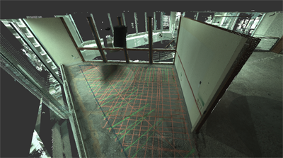
Colorized point cloud of the building and GPR markings
Case Study: Magnificent Mile Luxury Hotel
Location: Chicago, Illinois; One block from the Magnificent Mile
Task: The client is converting a 1980s office building to a luxury hotel, and needs to locate tension cables and rebar to accurately place mechanicals. To facilitate the design, the client needs precise documentation of the substructure and surrounding structural elements.
Challenge: When drilling for mechanicals, inaccuracies could result in costly, and sometimes, catastrophic results. Ground Penetrating Radar Systems Inc. (GPRS) uses ground penetrating radar to locate, identify and mark multiple areas of concrete on several floors, however manually documenting these physical markings to CAD can be tedious and lead to inaccuracies.
Solution: With TruePoint Laser Scanning, GPRS’s markings can be captured, in addition to all the elements of the surrounding structure, and aligned to the design model quickly and accurately. The combination of the laser scan and ground penetrating radar provides an overlay of multiple datasets, giving the client a high-definition 3D comprehensive view of the entire structure, both visible and invisible.
Deliverables: The client was provided with indexed point clouds for each floor in .rcp and .rcs file formats (ready to be used in Autodesk products). In addition, the client received AutoCAD 2015 2D floor plan drawings (in .dwg and .pdf file formats). The CAD drawings were aligned to the design drawings and included linework of the GPR markings and the point cloud x-referenced in.
Added Value: In addition to the main purpose of capturing GPRS’s markings, the laser scan provided as-built documentation to verify existing conditions of the structure and all of the remaining Mechanical, Electrical and Plumbing, and Architectural features. The client was able to use the point cloud data to compare against the construction documents, minimizing their drawing or modeling hours, and preventing errors and omissions.
If you have a project that requires mapping out a current site, creating accurate as-builts or is too complex or difficult to model manually, contact TruePoint Laser Scanning at 312-448-1509 or chicago@truepointscanning.com to discuss your needs.
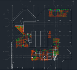
GPR markings overlaid into AutoCAD structural model
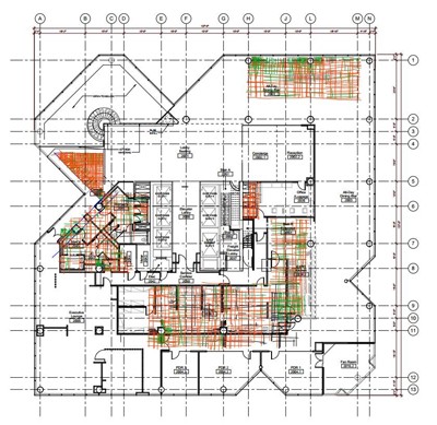
GPR findings captured by laser scanner and aligned to design model
