3D Laser Scan of the Underground Tunnel Systems
Case Study: Laser Scanning of Underground Utility Tunnels
Location: Ann Arbor, Michigan
Task: To map out the existing location and condition of underground utility tunnels in order to chart the locations of the utilities and to document the tunnels' elevations, slopes, and structural features.
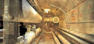
Challenge: Many of these tunnels were built in the early and mid-1900s and were not well-documented; therefore, it is difficult to know the tunnels' paths and what is in each section. Due to the conditions inside the tunnel system, including tight spaces, hard-to-reach areas, hard-to-see pipes, and the sheer expanse of the tunnel system, it was not feasible to manually map the tunnel structure and its contents.
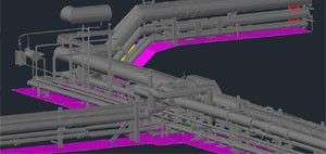
Solution: TruePoint's use of 3D laser scanning made it possible to capture information in the hard-to-reach and hard-to-see places. TruePoint then took the point cloud data from the scans and turned it into a layered 3D CAD model. This allows the user to analyze the data by turning off layers, such as walls, that were impeding the view of pipes and other utilities located inside the tunnel system. This method allows for the unique ability to see parts of the tunnel that are not ordinarily visible due to restricted view and/or area access. Additionally, by tying the scans to survey control both inside and outside the tunnel system, the user is now able to study the slope and elevations of the tunnel systems, as well as where these tunnels are located on state plane coordinates.
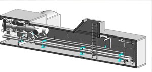
Deliverables for this project included the point cloud files, the 3D CAD model, a 3D Revit model, TruViews, and fly-thru videos of the tunnel system.
Added Value: Not only was TruePoint able to give the client valuable information about their underground tunnel system but, because every point is tied to state plane coordinates, the client also knows the exact location and elevation of every point within the tunnels. The scan also made it possible to identify cracks and their exact locations. Even though the tunnel system was on-site for the client, it would have been both time-consuming and difficult to gain authorization and access to the tunnels. Therefore, having models and 3D pictures of the tunnel, which can be viewed from the client's office, provides additional time saving benefits and avoids potential safety and health issues.
If you have a project that requires mapping out a current site, creating accurate as-builts or is too complex or difficult to model manually, contact TruePoint Laser Scanning at 734-807-0117 or annarbor@truepointscanning.com to discuss your needs.