How To 3D Laser Scan A Building

3D Building Scanning
To get precise measurements of a building or site, the best method is to 3D laser scan it. 3D laser scanning is becoming more integrated within the construction and engineering process. It is much more than a design tool, it is a way to unite a team to visualize a project.
3D laser survey offers a safe, fast and accurate solution to obtaining on-site building measurement data, which is supported by 3-dimensional imagery, making it ideal for building or construction design and project management applications.
3D Laser Scanning or Lidar
The process of 3D laser scanning or LiDAR occurs when the scanner transmits a laser beam and hits an object, at which point the light is reflected back and captured by the scanner. Because light travels at a constant speed, the variation can be calculated as a distance; therefore, producing an accurate point in space.
Scanners repeat this process up to a million times a second, creating a 3D image made up of millions of data points referred to as a point cloud. Point clouds create an accurate map of the shape and size of the building or site. Each point of the scan will be converted to a pixel with a known x-, y- and z- coordinate.
3D laser scanning offers a fast and accurate solution to obtaining on-site building measurement data.
What is the Process of 3D Scanning a Building?
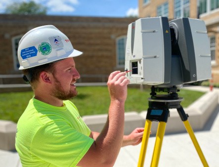
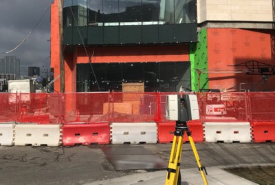
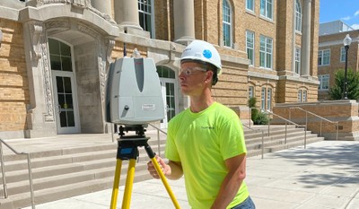
A scan technician arrives on-site and will position the laser scanner at multiple locations, capturing millions of measurements and documenting every project detail into a digital map or point cloud. 3D scanning is only as good as the person positioning the scanner. The scan technician must be trained and have project awareness. It is not always as simple as pressing a button and moving onto the next position in a random fashion, although it may look like this at times.
Why is a Point Cloud Important?
Point clouds provide powerful and dynamic information for a project. By representing spatial data as a collection of coordinates, point clouds deliver large datasets that can be mined for information. The visualization and analysis from point cloud data is invaluable for decision making.
Does the Data Need to be Processed?
With laser scanning complete, the data needs to be processed or registered. All of the individual scans taken by the scan technician need to be aligned and fit together. The registration process is similar to putting together a digital 3D puzzle, overlapping scan data and joining together the scan points. Once the scans are all registered, the combined deviations between the registered scans are totaled to provide an overall survey accuracy. Leica ScanStations can tie to survey control and achieve 2-4mm accuracy.

By representing spatial data as a collection of coordinates, point clouds deliver large datasets that can be mined for information.
What Can I Do With the 3D Scan Data?
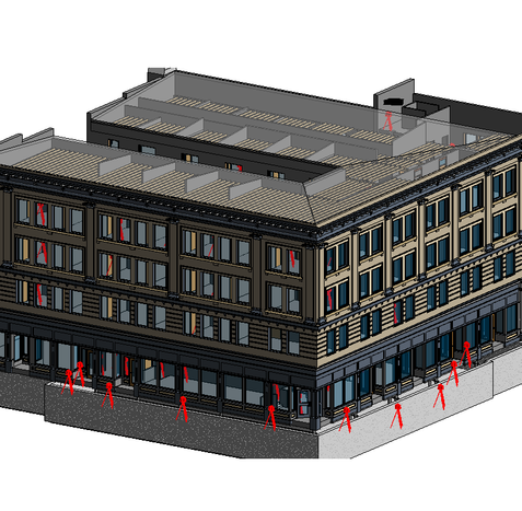
Some clients are able to utilize the point cloud data directly. 2D drawings and 3D BIM models can be created from the registered point cloud data by CAD technicians. A client’s 3D model can also be imported, overlaying it against the point cloud, this can save time and is a cost-effective way of identifying clash detection without having to model the whole building or site.
Many software applications also allow you to mesh the scanned data. This is a process that converts the point cloud into a digital solid object by triangulating points to form a surface. Meshes can then be processed as a 3D solid instead of a point cloud and have multiple uses in 3D CAD software.
3D scan data can be used for visualization, analysis, design, construction, renovation, prefabrication and facility modifications.
What are the Benefits of 3D Laser Scanning?
Buildings or sites are captured in high detail the first time, eliminating the need for return visits. High speed data collection expedites time-sensitive projects or those that require minimal disruption. Datasets are dimensionally accurate, measurable, and shareable, optimizing the efficiency of time spent during project planning and execution. Communication is improved, teams can discuss plans while each has access to the same information, creating a more dynamic work environment. Laser scanning allows you to minimize risk, design confidently and avoid change orders.
How Long Does 3D Laser Scanning Take?
An individual scan usually takes between 1-2 minutes. The scan technician will set up the scanner in multiple positions around the building or site. Most building scanning projects can be laser scanned in as little as a couple of hours or larger sites in a few days. Entire facilities or campuses can take several weeks to capture the entire site, but most projects are scanned in a few hours or one day.
Most building scanning projects can be laser scanned in one day on-site.
How Much Does 3D Laser Scanning Cost?
The cost of 3D laser scanning a building depends on the size and complexity of what is being scanned. Modeling costs are based on the size of the area being modeled, level of detail and features needing to be included. 3D laser scanning can bring tremendous cost savings to a project. Quality data can lead to a faster design process and fewer change orders, saving time and money. 3D laser scanning could lead to significant savings over the course of a project.
For more information on 3D building scanning services, call us at 419-843-7226 or email us at info@truepointscanning.com. We’re currently offering 10-minute presentations – would you like to schedule one? Click here.