All You Need to Know About Point Clouds
What is a Point Cloud in Laser Scanning?
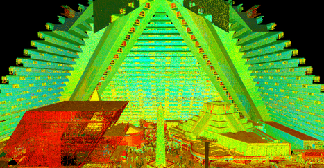
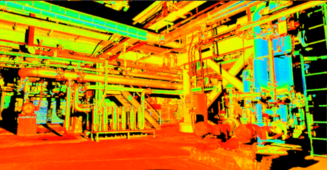
A point cloud is the step before an accurate 3D model of the real world is created. It’s the starting point for digital reality, a map of points in space which are processed to become 3D models of almost any object. At a large scale, this includes buildings, factories, manufacturing plants, civil infrastructure, historical sites and much more.
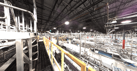
3D models based on point cloud data are being used in a growing number of industries for visualization, planning and customization. The data has the power to transform – and is transforming – the way that buildings are planned and maintained, improving the accuracy of information available to everyone from architects to operations managers.
To increase understanding of this important technology, let's go back to the basics to look at the whole point cloud process, covering:
- What does point cloud scanning contain
- How it's generated
- Some ways that point cloud data is used now, and
- How we predict it will be used in the near future.
What is a LiDAR point cloud?
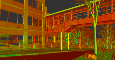
A point cloud is a collection of an enormous number of measurements: a set of data points or coordinates in three dimensions. The measurements are made by 3D laser scanners and Light Detection and Ranging (LIDAR) technology. A laser measures where light hits surfaces within its line of sight. To give a sense of the huge number of points taken, the Leica RTC360 3D laser scanner has a measuring rate of up to two million points per second. It can create an HDR-colored 3D point cloud of its environment in under two minutes. Let’s look at how it creates a point cloud in more detail.

A point cloud is a collection of an enormous number of measurements: a set of data points or coordinates in three dimensions.
How is a point cloud made?
With a 3D laser scanner. Laser scanners are portable, fast and precise. The scanner itself sits on top of a tripod, set up within view of what needs to be measured and a technician begins the data collection process. For the RTC360, a high-speed rotating mirror allows extremely high measurement rates and a Visual Inertial System (VIS) with clever algorithms tells the scanner where it is – its relative position and orientation – when it is moved between different setups.
There are many different laser scanning systems available to create a point cloud. Among many types of scanners including mobile mapping and UAV technology, TruePoint uses industry-leading Leica professional-grade laser scanners to capture the highest quality 3D data for a project. Leica Geosystems offers a range of different types of 3D terrestrial laser scanners to suit different situations – Leica ScanStation P-Series for long ranges and scanning at a safe distance, through to the more portable Leica RTC360 laser scanner.
How do you use point cloud scan data?
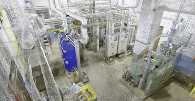
A point cloud needs to be processed to create a complete 3D composite point cloud of the existing conditions. In reality capture terminology, you need to register, or stitch together, the final data.
Point cloud registration is where you align overlapping point clouds – if you moved your laser scanner to different positions on site to capture a larger or more complete scene – to cover gaps formed from line of site shadows of the area.
Some of the points collected won't be needed, and further processing can filter and refine your data. For example, if you scan a shopping center, you will capture a lot of people moving around. Cleaning the data via scanning techniques or other post processing steps in final registration will remove these undesired ghost objects so that you have a cleaner, smaller and less noisy dataset.
The technology to create and process point clouds is getting easier to use
What is a point cloud used for?
The point cloud data can be used in different formats as an actual point cloud filetype and its associated HDR images. Further, it can be converted into 3D objects such as surfaces, triangulated meshes, or vector objects such as 3D solid models and even 2D drawings. Additionally, custom deliverables can be created for a whole variety of analyses. For project storage that enables 3D data visualization and collaboration on the web, the new Cyclone ENTERPRISE provides a central source of truth for project stakeholders.
Once point cloud data becomes a composite 3D entity, its benefits are unlocked. These differ by industry and application but are mainly based on having accurate site data. Here are a few examples in a few industries where point clouds are commonly used.
Engineers and architects can use Revit software to efficiently and accurately create a Building Information Model (BIM) of an existing structure or update original design models with real-world conditions post-construction. When working on retrofit design projects, they can experience a virtual site and check for conflicts with the existing conditions. This helps stop critical errors in their tracks before they slow or halt a project.
In public safety projects, point cloud data can lead to more accurate modeling. For example, a flood prevention project used laser scanning to evaluate the effects of projected safety measures and experiments in landscaping. In archaeology, point cloud data can provide accurate data on existing conditions of site structures to help conservation and restoration planning or help researchers develop a clearer view of a site’s scale and layout.
What will the future look like for point clouds?
The technology to create and process point clouds is getting easier to use. For example, ten years ago, on a construction site, it would take two or three surveyors a day to create a point cloud using a laser scanner the size of a chest freezer. Now, with laser scanners like the Leica RTC360, scans are done within minutes.
Coupled with the ability to process and store larger amounts of data than ever before, point clouds are becoming accessible to more users. In areas like construction, where point clouds are commonly used, the scale of what’s captured will increase. For example, we can now create a digital reality from a whole city mixing airborne and earthbound data captures, creating huge opportunities for the future of urban planning.
Point cloud scanners will be used in more industries via visualization by VR. VR based on point cloud data will be more realistic, more accurate and more engaging. Not just used in entertainment, VR has many serious applications where it is useful to be at a location but may be too expensive or dangerous to visit. These include training, allowing you to learn visually and make mistakes, exploration of historical sites, without disturbing or eroding them and even investigation of a crime scene that has been cleared and no longer exists.
Finally, innovation will continue at pace in reality capture technology and in point cloud processing. It’s common for scanners to be used in UAVs and mobile mapping solutions. In the future, terrestrial laser scanners will become more automated, with users needing to spend less time on site.
Using robotics, scans could be carried out by a specialist surveyor on the other side of the world. Looking even further ahead into a world of ‘big point cloud data’ machine learning and AI will eventually automate the interpretation of point clouds. Computers will be programmed to detect certain objects in models as part of an intelligent workflow, saving a huge amount of time and increasing the amount of data that it’s possible to process.
For more information on point clouds, point cloud scanning or 3D laser scan technology, contact TruePoint Laser Scanning today at 419-843-7226 or email info@truepointscanning.com.
Engineers can use Revit software to efficiently and accurately create a Building Information Model (BIM) of an existing structure.
This article was provided by Leica Geosystems' Blog: The High Definition Surveyor.
https://blog.hexagongeosystems.com/all-you-need-to-know-about-3d-point-clouds