A Complete Guide to the 3D Laser Scanning Process
Want to learn more about 3D laser scanning, the equipment used for data collection, and steps of the laser scanning process? 3D laser scanners are powerful instruments capable of mapping a space in exact 3D detail. This kind of reality capture delivers huge advantages for all kinds of construction and engineering projects.
Below is a comprehensive guide created to provide more information on 3D laser scanning, terrestrial laser scanners, and the steps of the laser scanning process.
WHAT IS 3D LASER SCANNING?
3D laser scanning uses LiDAR technology to accurately capture three-dimensional data of a structure or site. LiDAR (light detection and ranging) technology sends light in the form of a pulsed laser to measure distances to a target. The reflected laser rays return back to the scanner, and the distance is recorded, capturing the spatial geometry of the structure or site. Millions of measurement points are collected, each containing an x, y, and z coordinate.
Together, the points create a point cloud. The intricate detail of these data points allows clients to obtain an exact measurement from any one point to any other point in the point cloud. Point cloud data can be used to generate 2D CAD drawings and 3D BIM models of buildings and sites for construction and engineering projects. Read more about 3D laser scanning, here.
WHAT SCANNERS ARE USED FOR DATA COLLECTION?
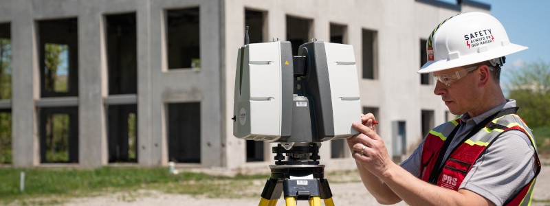
A terrestrial laser scanner is used for data collection, as they are able to easily document vertical structures, such as buildings and facilities. These scanners sit on a tripod and can take 1-3 minutes to complete each scan, depending on the project requirements. Terrestrial laser scanners are known to produce the most accurate point clouds due to the fact that they are stationary. Note that a laser scanner can only capture what is in its field of view. Scanners are positioned around a site and take individual scans from varying viewpoints to capture complete site data. The captured points record everything from surface detail and texture, to color, creating a direct representation of the scanned project site. Read more about the equipment used for data collection, here.
WHAT ARE THE STEPS OF THE 3D LASER SCANNING PROCESS?
3D laser scanning captures as-built documentation of buildings and sites with high precision. Project Managers need extensive knowledge and experience to understand the 3D laser scanning process and use it successfully. GPRS/TruePoint Project Managers go through a formal training program to develop mastery of equipment and methods, increase field knowledge, and provide the best deliverables for every project. The laser scanning process at GPRS/TruePoint follows these steps:
-- Define Project Scope – The Project Manager meets with each client to understand their project scope and provide optimal solutions based on the project requirements.
-- Conduct Site Walk – The Project Manager walks the project site to familiarize themselves with the scope and create a plan for complete data capture. The Project Manager will ensure coverage of the scan area from all angles and work around obstructions. This process includes determining the scanner set-up locations, planning the workflow, documenting obstacles and intricate MEP, and estimating the time needed on-site.
-- Data Capture – Highly-trained Project Managers efficiently scan each site with Leica laser scanners. Leica scanners are positioned around the site and take individual scans from varying viewpoints to capture complete site data.
-- Registration – With the scanning complete, the data needs to be processed. The individual scans are aligned and fitted together. CAD technicians register and process the point cloud, removing noise and setting the coordinate system to provide the most precise measurements.
-- Quality Checks – A registration QA/QC check is performed to make sure all the scans fit together exactly as they should, ensuring the point cloud and models have tight lines and accurate measurements.
-- CAD/BIM Development – Point cloud, 2D drawings and 3D models are created in-house and QA/QC checked to make sure they are precise. Deliverables can be provided at any level of detail in a variety of formats including Revit, AutoCAD, ReCap, Navisworks, Civil 3D, BIM 360, A360, FARO As-Built, JetStream Viewer, and NavVis.
-- Data Transfer – Data is efficiently transferred to clients via Sharefile, Cloud platforms, or mailed on a hard drive.
For More Information on 3D Laser Scan Technology
3D laser scanning offers an accurate solution to obtaining on-site measurement data for construction, engineering and design projects. Terrestrial laser scanners are known to produce the most accurate point clouds. Highly trained Project Managers ensure successful data capture, registration, and CAD/BIM deliverable creation. Read our FAQ's, here.
For questions on 3D laser scanning, terrestrial laser scanners, and the steps of the laser scanning process, contact TruePoint today at 419-843-7226 or email info@truepointscanning.com.