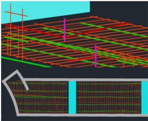
Example of the projects laser scanning deliverables.
Case Study: 3D Laser Scanning Used to Locate and Permanently Document Underground Utilities
Location: Parking garage in Beckley, West Virginia
Task: While following behind Ground Penetrating Radar Services, TruePoint Laser Scanning's task was to create a permanent record of the locations of rebar, post-tension cabling, and electrical conduit in and under the concrete of a parking garage structure and then document GPRS's findings in a 3D CAD model.
Challenge: Ground Penetrating Radar Systems uses radar to locate steel rebar, post-tension cabling, electrical conduit, utilities, etc., underground and in concrete. Typically, GPRS marks their findings directly on the surface in a temporary manner. However, in order to save time and money in the future, clients sometimes request to have this information permanently recorded in a useable and accurate format.
Solution: By combining GPRS’s radar technology with TruePoint's laser scanning technology, GPRS’s markings could be documented into a 3D CAD model, creating a permanent record of the rebar, post-tension cabling, and electrical conduit locations in and under the concrete of the structure. TruePoint used their laser scanner and followed behind as GPRS located and marked their findings directly on the concrete. Using the 3D laser scanner's findings, TruePoint was able to create a 3D CAD model which not only showed the location of the findings, but also captured the details of the surrounding walls, floor, ceiling, etc. Now, the client has a permanent record of these findings, which can be used at any time in the future to accurately locate and measure any points in the structure.
Deliverable: TruePoint provided the client with a point cloud, as well as TruView, 3D CAD, and 3D Revit models.
Added Value: Because of the accuracy and efficiency of TruePoint's laser scanning, GPRS’s findings were permanently recorded so that this information can be used in the future, without the need to rehire GPRS to locate these same findings again. Additionally, the client has a highly accurate record of these findings in the form of point clouds and 3D models of the structure's space. This means that the client is able to take measurements to and from any points of interest in the structure. Furthermore, by having this information in the form of a 3D CAD model, the client, engineers, architects, and anyone else involved will be able to overlay this data into their own software in order to assist with both the planning and implementation phases of a project.
If you have a project that requires locating and permanently documenting underground utilities or rebar, post-tension cabling, and electrical conduit, contact TruePoint Laser Scanning, Inc., at 703-835-5226 or washingtondc@truepointscanning.com.
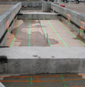
Ground Penetrating Radar and 3d Laser Scanning used in combination.
